Maui County introduces 3D mapping

Key Takeaways
In Maui County, the views go a long way.
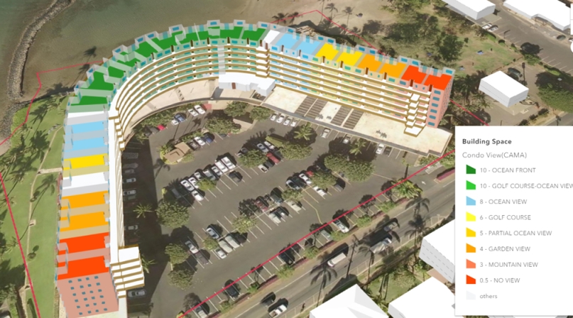
To the Maui County government, those views are crucial to determining how much a property is worth and how much will be generated in property taxes. By using three-dimensional modeling to visualize property data, the county is now able to better ensure that its assessment data is correct. But this technology can be applied to other county departments, too.
“For Hawaii, the view drives value more than anything else,” Finance Director Scott Teruya said. “Having an ocean-front view means property is more valuable. I looked at some units that records said they had a golf course view and it was clearly an ocean view, but being able to see the data made it more clear to us.”
Maui County is the first in the nation to completely map each multi-level condominium building in the county and others, including several counties in Florida, are following suit. Prior to Esri Canada’s complex 3D modeling job of the Vancouver peninsula in 2013, the industry standard in 3D modeling was to use single shapes to represent buildings. Now, each unit in a building can be individually represented, allowing for a greater level of detail.
“You couldn’t do too much, analytically, with those 3D models,” said Elton Yuen, Esri’s director of assessment business development. “We now build models based on actual condominium plans, and we build them floor by floor, unit by unit. Not only do we model each unit, we also model the common areas, elevators, staircases, lobbies, parking garages and in Florida, we add boat slips.”
Pinellas County, Fla. Property Appraiser Mike Twitty had Esri build 3D models of all four-story condo buildings built after 1990 and has been impressed by the result.
“It’s part of what the future holds for the assessment industry,” he said. “Whenever you can visualize data, it really helps, and there’s no better way to do that than to bring your whole world to life. Analyzing views in high-rise structures is always difficult and the way they design modern condominiums now it’s not easy to tell whose balcony belongs to who. The units have odd shapes with multiple balconies and view orientations.
“Ultimately the bottom line is to get our assessments to be more fair and equitable and this will help us do that.”
Assessment offices can assign colors to different features of a property — assessed value, sales price, square footage, number of bathrooms — and see those qualities represented by a different color.
“It allows the assessor to look for exceptions or errors,” Yuen said. “If certain patterns show up that don’t seem to make sense, they can catch it right away.”
On its face, the investment, which has cost Maui County roughly $400,000, is a double check on the work it has done over decades, totaling tens of thousands of units.
“You find so many inconsistencies (in records) that that alone helped with data standards,” Teruya said. “Not only are we getting wrong data out, we’re probably putting wrong data in and now we know.”
But the base has been established for other county departments to build off of the framework that had been designed for the assessor’s office.
“Once you do this, you’ve built a platform for everyone to use,” Teruya said. “As other people use this data, it will be amazing how we break down our silos. Other departments put their layers on this so now you can see how deep your water lines are to make sure you don’t break them, or a fire department will know on its way to a call where the fire hydrants are, where the shutoff valves are.”
Twitty echoed Teruya’s optimism for the maps to enhance public safety.
“The firemen on their way to a call will be able to see online how to navigate the inside of a building, where the stairwells are for different parts of the building, and they won’t be going in blind.”
Twitty doesn’t plan to commission 3D modeling for the entire county for assessment purposes, but he plans to pitch the concept to other departments to use for their own needs.

Attachments
Related News

U.S. House Appropriators release minibus funding package
The funding package includes key county priorities, including funding for community and economic development, election administration and security, taxpayer services and intergovernmental partnerships.

County Countdown – Dec. 15, 2025
Every other week, NACo's County Countdown reviews top federal policy advocacy items with an eye towards counties and the intergovernmental partnership.

